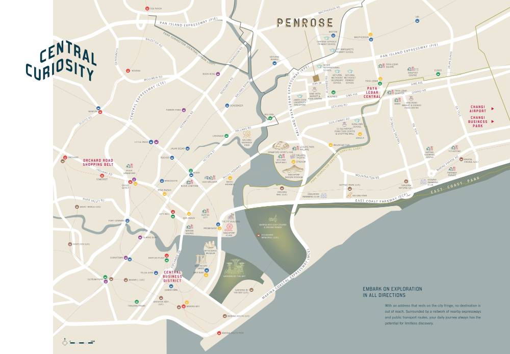
Location Map
Nearby Places
Primary Schools
- Geylang Methodist School (Primary) (0.47 km)
- St Margaret's Primary School (0.73 km)
- Canossa Catholic Primary School (0.9 km)
- Kong Hwa School (1.28 km)
- Bendemeer Primary School (1.66 km)
Secondary Schools
- Nexus International School (Singapore) (0.31 km)
- Broadrick Secondary School (1.54 km)
- NorthStar Gymnastics & Fitness (1.66 km)
- Cedar Girls' Secondary School (1.82 km)
- St Andrew's Secondary School (2.02 km)
MRT Stations
- Aljunied MRT station (0.45 km)
- Geylang bahru MRT station (0.91 km)
- Mattar MRT station (0.98 km)
- Kallang MRT station (1.23 km)
- Mountbatten MRT station (1.44 km)
Nearest Hospitals & Clinics
- Jin On Chinese Physician Acupunturist and Physiotherapy Centre (0.14 km)
- Aestmod Auto (0.76 km)
- Bes Technology Pte Ltd (0.8 km)
- Vivo Enterprise Pte. Ltd. (0.96 km)
- Sian Chay Medical Institution (1.1 km)
Parks & Recreation
- Katong Dog Run (2.58 km)
- Katong Park (2.67 km)
- Toa Payoh Sensory Park (3.49 km)
- Fountain of Wealth (3.53 km)
- Bay East Garden (3.58 km)
Supermarkets
- Sheng Siong Supermarket (0.68 km)
- Sheng Siong Supermarket (0.85 km)
- I-Tec Supermart Pte Ltd (0.85 km)
- Giant Supermarket - Paya Lebar Square (1.46 km)
- Prime Supermarket (1.73 km)
Sims Drive area situated off Aljunied Road is an upcoming iconic lifestyle enclave. It features Sims Drive Road that connects to Aljunied Road lining to Sims Avenue. Sims Avenue is a one-way road linking Kallang Road to Jalan Eunos. The Road and possibly the area were named Sims in honour of a local Chinese businessman, Sim Kia Jan. Sim Kia owned a portion of land close to the area.
Sims drive sits in District 14 of Singapore that comprises Pay Lebar, Geylang, and Eunos. These areas have played a big role in shaping Singapore’s history. It houses iconic buildings and structures that reflect the unseen part of Singapore. To retain the district’s rich history, some of its cultural and historical elements have been conserved by the government. However, other parts are set apart to pave the way for the construction of modern redevelopment projects.
The nearby Eunos area was initially known as Kampong Eunos. Today, the area portrays a blend of modernity and tradition. It houses intricately designed religious buildings such as the Mangala Vihara Buddhist Temple, and the Masjid Darul Aman mosque. The modern elements featured in the area include the Eunos Market Food Centre providing various delicious local foods and Kampong Ubi Community Centre, which offers Malay art and culture classes.
Geylang area derived its name from “geylanggan”, which is a Malay word that means to crush or twist refers to the procedure of extracting the coconut milk and flesh used to thicken curries like in Peranakan cuisine by the locals. Also known as Geylang Serai, this area is situated towards the east of the Central Area. The huge number of foreign workers’ quarters, busy shophouses, and many karaoke lounges is a good display of Singapore’s modern look. The historic shophouses here give a taste of the 1970s with their original looks. Today, Geylang is increasingly becoming popular by locals and expats due to the high number of new property launches. At least 40 projects featuring up to 2,190 units were expected to be launched by the end of 2017.
Paya Lebar refers to a wide swamp in the Malay language. The area used to be a squatter area with poultry and pig rearing before the establishment of British colonial rule in Singapore. Fast forward, today the area features commercial workshops, offices and small retail shops. Several business activities happen in the area, and it has been identified with technological advancements.
Sims Drive features both private and public housing with several shophouses. It is known for its strategic location close to a plethora of amenities, including schools, shopping malls, restaurants and more. The area is well connected across the neighbourhood and with other parts of Singapore through the established roads, expressways and MRT lines.
